EN
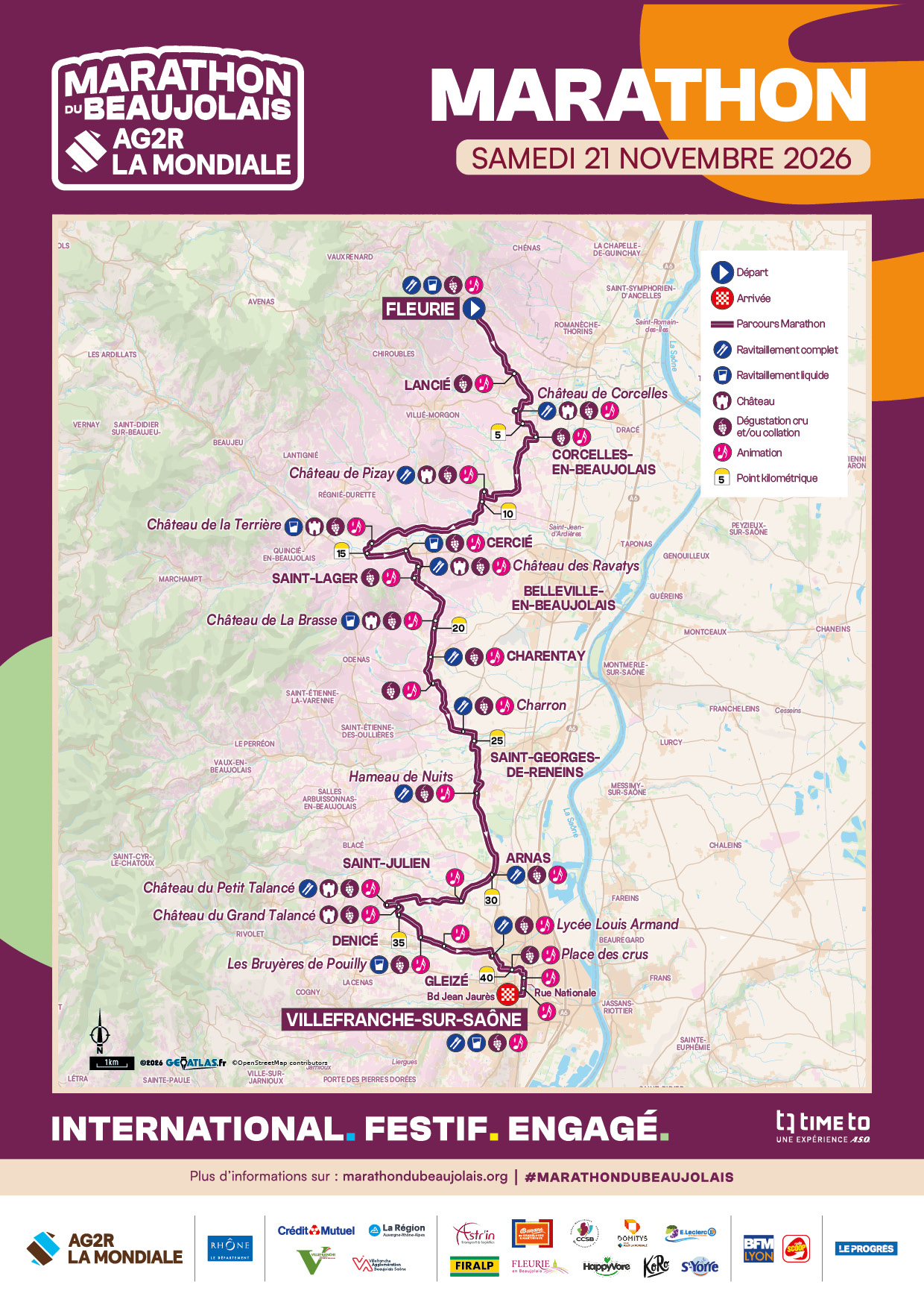
Race course · Beaujolais Marathon 2026
Beaujolais Marathon: elevation profile, gain and race strategy
The Beaujolais Marathon runs from Fleurie to Villefranche-sur-Saône, two days after the release of the Beaujolais Nouveau, through vineyards, châteaux and brass bands. It's known as a party, and it is one. But it's not a flat marathon: it goes down more than it goes up, and its hardest climbs come after km 30. Here is the course as Runcon reads it, kilometre by kilometre.
Updated 27 October 2026 · race on Saturday 21 November 2026
Race facts
| Date | Saturday 21 November 2026, start at 8:30 (22nd edition) |
|---|---|
| Start | Fleurie, opposite the Maison du Cru |
| Finish | Villefranche-sur-Saône |
| Distance | 42.195 km, 95% on small roads |
| Elevation | No official figure · 376 m D+ and 495 m D− measured by Runcon |
| Altitude | 180 to 302 m (measured by Runcon) |
| Time limit | 7:30 (finish closes at 16:00), cut-offs at halfway and at Arnas (km 30) |
| Field | 4,500 in the marathon in 2025, 33,000 runners over the weekend |
| On the course | 15 aid stations, 18 wine tastings, 35 bands |
The course profile, analysed by Runcon
Here is the course as Runcon displays it when you add a race: each stretch is coloured by the effort it takes on the road. The organiser doesn't publish a GPX: the route used here is the one listed as official on Finishers, which follows the 2026 map, with elevations from IGN, the French national mapping agency.
OpenRunner route listed by Finishers (2022 edition, reused in 2025, same shape as the 2026 map), with elevations recalculated on the IGN terrain model. Vertical scale from 150 to 330 m. The dotted lines mark the full aid stations at the kilometres given in the 2025 runner's sheet: the 2026 guide isn't out yet.
Four steep climbs, the hardest at km 17
Runcon's briefing looks for steep climbs (over 4% on the road), very steep ones (over 6%), steep descents and uphill false flats. On the Beaujolais, here is what it finds:
| Climb | Km | Length | Gradient |
|---|---|---|---|
| Towards Château de Corcelles | 4.3 – 4.7 | 400 m | 4.1% |
| From Cercié to Château des Ravatys | 16.7 – 17.0 | 300 m | 6.8% |
| After Château de la Brasse | 21.5 – 21.8 | 350 m | 4.6% |
| Towards the Talancé châteaux | 33.0 – 33.6 | 500 m | 5.3% |
None of them is long: 300 to 500 m. What matters is where they fall. The steepest comes before halfway, while you still have legs. The most costly is the Talancé climb at km 33: it's part of a five-kilometre block that gains 80 m, just when the marathon gets hard for everyone.
The five parts of the course
| Part | Km | D+ | D− |
|---|---|---|---|
| Fleurie, Corcelles and Pizay | 0 – 10 | 86 m | 154 m |
| Cercié, Brouilly and La Brasse | 10 – 21 | 94 m | 116 m |
| Charentay, Saint-Georges and Arnas | 21 – 30 | 58 m | 79 m |
| Saint-Julien, Talancé and Denicé | 30 – 36 | 113 m | 49 m |
| Gleizé and Villefranche | 36 – 42.2 | 25 m | 96 m |
Elevation gain (D+) and loss (D−) measured by Runcon, IGN elevations.
1. Fleurie, Corcelles and Pizay (km 0 to 10): the deceptive descent
The start is the highest point of the course (302 m). The first two kilometres drop more than 80 m, at over 4% on average: with the excitement of the start and the crowd, it's the best way to reach km 2 a minute ahead with your quads already hurting. Let it roll without pushing. After that, it undulates: a short steep climb towards Château de Corcelles (km 4.5), then a longer, gentler one towards Château de Pizay (km 7 to 10). Aid stations at Corcelles (km 4) and Pizay (km 10).
2. Cercié, Brouilly and La Brasse (km 10 to 21): the steepest climb
After a descent to La Terrière (km 15) and Cercié station, the course tackles the steepest climb of the day: 300 m at almost 7% towards Château des Ravatys, at the foot of Mont Brouilly (km 17). Take it with shorter strides, by effort: over 300 m, walking a few steps costs almost nothing, while going into the red costs a lot. The descent that follows (km 18 to 19.5) lets you recover. You pass Château de la Brasse around halfway.
3. Charentay, Saint-Georges and Arnas (km 21 to 30): the rolling part
One last short, steep climb just after La Brasse (km 21.5), then the calmest part of the course: Charentay, Charron, Saint-Georges-de-Reneins and Hameau de Nuits, slightly downhill to the low point at Arnas (km 30, around 185 m). Time to settle into your rhythm and fuel well (Charron km 24, Hameau de Nuits km 27, Arnas km 30): what comes next climbs.
4. Saint-Julien, Talancé and Denicé (km 30 to 36): where the race is decided
Six kilometres that gain 113 m, almost a third of the course's total climbing. A moderate climb around km 31.5, then the steep climb towards the Talancé châteaux (km 33 to 33.6), followed by more than a kilometre at 2% up to km 34.8. After a short descent, one last bump towards Denicé (km 35.6 to 36.2). This is where your pace will drop the most: don't try to hold it, hold your effort. Aid station at Petit Talancé (km 34).
5. Gleizé and Villefranche (km 36 to 42.2): the gently sloping finish
The hardest part is done: the course loses almost 100 m over the last six kilometres, including a long descent between km 36.5 and 39. If your quads survived the start, this is where you claw time back. Just before the finish, the Avenue des Crus offers a tasting of each of the ten Beaujolais crus. Your call.
Aid stations, wine tastings and cut-off times
The organiser announces 15 aid stations and 18 tastings of Beaujolais Nouveau. The full aid stations on the 2026 map are at Fleurie, Château de Corcelles, Pizay, Les Ravatys, Charentay, Charron, Hameau de Nuits, Arnas, Petit Talancé, Lycée Louis-Armand and the finish. Water points are added at La Terrière, Cercié, La Brasse and Les Bruyères de Pouilly.
The time limit is 7 hours 30 (the finish closes at 16:00). There are two cut-offs, at Château de la Brasse (around halfway) and at Arnas (km 30): the website says 12:15 and 13:45, the race rules 4 hours and 5 hours 30 of racing, i.e. 12:30 and 14:00. Go by the stricter times. Pacers cover targets between 3:15 and 4:30 (the exact list varies between sources).
The start is on the road opposite the Maison du Cru in Fleurie, in two waves. Shuttles leave the Parc Expo in Villefranche early in the morning: you don't need to go back to Fleurie for your car.
How fast the front runners go
| Edition | Men | Women |
|---|---|---|
| 2025 | Jérémy Mansuy, 2:26:31 | Perrine Géraud, 2:58:54 |
| 2024 | Jérémy Mansuy, 2:27:54 | Perrine Géraud, 3:03:21 |
Jérémy Mansuy won in 2025 for the third year running. The winning times, slower than on a flat marathon, show what the terrain is worth: you don't come here for a record, you come to run smart.
The weather in late November
In late November around Lyon, averages are about 5 °C in the morning and 11 °C in the afternoon. In 2025, the organiser described "polar cold". With an 8:30 start at the top of Fleurie, bring a layer for the start, and remember that the downhill first two kilometres won't warm you up.
Plan your finish time with Runcon
The profile above is what Runcon shows for any race as soon as you drop in its GPX. In the app, you also get an estimated finish time based on your level that accounts for every climb and descent, your split times kilometre by kilometre and at the aid stations, and a pre-race briefing that tells you where your pace will shift. On a course like the Beaujolais, that's what stops you from aiming for your flat-marathon pace.
No GPX yet? Our GPX file guide explains where to find one and how to draw one in the meantime.
Frequently asked questions
- When is the Beaujolais Marathon in 2026?
- On Saturday 21 November 2026, starting at 8:30 in Fleurie and finishing in Villefranche-sur-Saône. The half marathon starts the same day at 10:00, and the trail races are on Sunday 22.
- Is the Beaujolais Marathon hard?
- Harder than a city marathon: Runcon measures 376 m of D+ and 495 m of D−, with four steep climbs, including one at almost 7% at km 17. The hardest stretch is between km 30 and 36. Details above.
- Can I still sign up?
- In mid-October, the half marathon and the 13 km were sold out, and bibs remained for the other races. The marathon was at the €99 "Last Minute" price. Check on the Time To registration platform.
- Where and when do I collect my bib?
- At the Parc Expo in Villefranche (221 avenue de l'Europe), on Thursday 19 November from 12:00 to 20:00 and Friday 20 from 10:00 to 20:00. There is no collection on race day.
- Do I need a licence or a medical certificate?
- An FFA (French Athletics Federation) licence or a PPS certificate (Parcours Prévention Santé, the French online health-awareness course) less than a year old, validated online or shown at bib collection. Foreign licences are not accepted.
Sources
- 2026 marathon page (marathondubeaujolais.org)
- 2026 course map and 2025 runner's sheet (marathondubeaujolais.org)
- 2026 race rules (in French)
- 2025 edition press release (marathondubeaujolais.org)
- Marathon GPX route (finishers.com) · elevations: IGN, RGE ALTI
Running the Beaujolais? Plan your pace first.
Drop the GPX into Runcon: you'll know where your pace will shift, and the finish time the course really allows you. Your first 3 analyses are free.